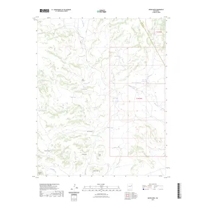
2023 Map of Medina Mesa
USGS Topo · Published 2023About this map
Medina Mesa and its surrounding canyons define this high-desert landscape along the border of San Miguel and Harding counties. The area is characterized by a complex network of intermittent drainages, including the prominent Atarque Creek and Portales Creek, which have carved deep features like Medina Canyon and Monia Canyon. Named landmarks such as Miller Peak and Gobblers Knob provide essential navigational points in a territory where water management is critical, as evidenced by several livestock tanks such as Tanque Grande, Blue Tank Number One, and Antelope Tank. The presence of Co RD J-1 and Co RD C-4 provides the primary access through this rangeland, connecting the various mesas and canyons that have likely supported grazing and transit for generations.
Find a feature on this map
25 named features on this map. Tap any name to fly to it.
Don’t see what you’re looking for? This feature index may not catch every label — zoom into the map to look around manually.
Map Details
Editions of this 2023 Medina Mesa Map
This is the sole edition of this map. No revisions or reprints were ever made.
Other maps of this area

1930 · Tucumcari
USGS Topo · 1:125,000

1954 · Tucumcari
USGS Topo · 1:250,000

1958 · Tucumcari
USGS Topo · 1:250,000

1967 · Trinchera Creek
USGS Topo · 1:24,000

1968 · Bascom Camp
USGS Topo · 1:24,000

1968 · Hampton Ranch
USGS Topo · 1:24,000

1968 · Carpenter Mesa SW
USGS Topo · 1:24,000

1968 · Carpenter Mesa NW
USGS Topo · 1:24,000
1968 · Medina Mesa
USGS Topo · 1:24,000

1969 · Gallegos
USGS Topo · 1:24,000