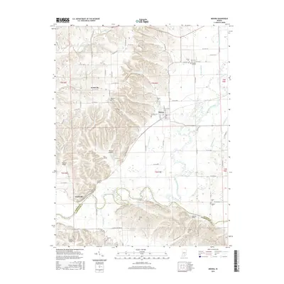
2016 Map of Medora
USGS Topo · Published 2016About this map
Medora serves as the central hub of this Jackson County landscape, situated on the edge of the broad East Fork White River valley. The map reveals a complex network of drainage ditches such as McHargue Ditch and Hinderlider Ditch, reflecting long-term efforts to manage the fertile lowlands of Buffalo Bottoms and the Muscatatuck River confluence. Higher ground to the west is marked by numerous family-named landmarks and hollows, including Shelton Hollow and Fleene Ridge. This area is particularly rich for genealogical research, documenting numerous small burial sites like Heighton Hill Cem, Lanning Spurt Cem, and Pollock Cem that are scattered across the townships. Smaller settlements like Weddleville and Sparksville anchor the rural roads, providing a clear picture of the human footprint across the varied terrain of Jackson and Washington counties.
Find a feature on this map
93 named features on this map. Tap any name to fly to it.
Don’t see what you’re looking for? This feature index may not catch every label — zoom into the map to look around manually.
Map Details
Editions of this 2016 Medora Map
This is the sole edition of this map. No revisions or reprints were ever made.
Other maps of this area

1934 · Bedford
USGS Topo · 1:48,000

1937 · Bedford
USGS Topo · 1:62,500

1951 · Smedley
USGS Topo · 1:24,000

1953 · Kossuth
USGS Topo · 1:24,000

1956 · Vincennes
USGS Topo · 1:250,000

1957 · Vincennes
USGS Topo · 1:250,000

1957 · Campbellsburg
USGS Topo · 1:24,000

1958 · Vincennes
USGS Topo · 1:250,000
1958 · Norman
USGS Topo · 1:24,000

1958 · Brownstown
USGS Topo · 1:24,000