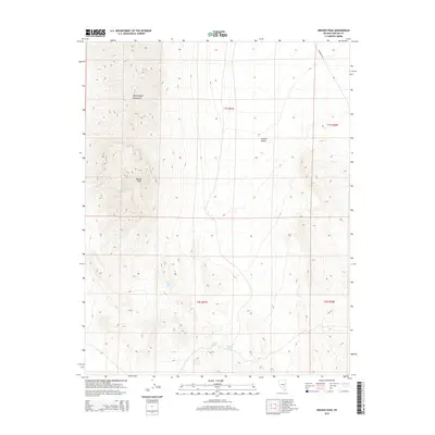
2015 Map of Meeker Peak
USGS Topo · Published 2015About this map
Meeker Peak and the high ridges of the Worthington Mountains dominate this high-desert landscape in Lincoln County. The map details the sharp elevation changes between the peaks and the surrounding basins, including the western edge of Garden Valley. Water sources are critical landmarks in this arid environment, with small perennial or seasonal features such as Stink Bug Spring, Modes Spring, and Rhodes Spring appearing at the base of the mountain slopes. Human presence is limited to remote access routes like Freeburg Rd, highlighting the wilderness character of the Great Basin during this mid-2010s survey. The Public Land Survey System grid, including t1s r57e and t1s r58e, provides a formal framework over the natural topography of the basin and range province.
Find a feature on this map
11 named features on this map. Tap any name to fly to it.
Don’t see what you’re looking for? This feature index may not catch every label — zoom into the map to look around manually.
Map Details
Editions of this 2015 Meeker Peak Map
This is the sole edition of this map. No revisions or reprints were ever made.
Other maps of this area

1942 · Penoyer Valley
USGS Topo · 1:125,000

1954 · Caliente
USGS Topo · 1:250,000

1959 · Caliente
USGS Topo · 1:250,000

1964 · Tempiute Mtn
USGS Topo · 1:62,500

1985 · Worthington Peak
USGS Topo · 1:24,000

1985 · McCutchen Spring
USGS Topo · 1:24,000
1985 · Mount Irish
USGS Topo · 1:24,000

1985 · Murphy Gap
USGS Topo · 1:24,000

1985 · Worthington Peak SW
USGS Topo · 1:24,000

1985 · Murphy Gap NW
USGS Topo · 1:24,000