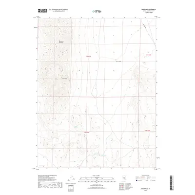
2018 Map of Meeker Peak
USGS Topo · Published 2018About this map
Meeker Peak rises as the prominent landmark of this high-desert terrain, anchoring the southern reaches of the Worthington Mountains. This 2018 survey reveals a landscape defined by dramatic elevation changes and sparse water sources, where the vast Garden Valley spreads to the east. Modern mapping techniques by the U.S. Geological Survey detail the public land survey system grid, which organizes this part of Lincoln County into distinct townships. Historical travel routes are represented by Mail Summit Rd in the northeast corner, a corridor through the high basins. For those studying the hydrology of the Great Basin, the map identifies critical desert water points including Stink-Bug Spring, Modes Spring, and Rhodes Spring, which have long served as vital stops for both wildlife and travelers in this arid environment.
Find a feature on this map
11 named features on this map. Tap any name to fly to it.
Don’t see what you’re looking for? This feature index may not catch every label — zoom into the map to look around manually.
Map Details
Editions of this 2018 Meeker Peak Map
This is the sole edition of this map. No revisions or reprints were ever made.
Other maps of this area

1942 · Penoyer Valley
USGS Topo · 1:125,000

1954 · Caliente
USGS Topo · 1:250,000

1959 · Caliente
USGS Topo · 1:250,000

1964 · Tempiute Mtn
USGS Topo · 1:62,500

1985 · Worthington Peak
USGS Topo · 1:24,000

1985 · McCutchen Spring
USGS Topo · 1:24,000
1985 · Mount Irish
USGS Topo · 1:24,000

1985 · Murphy Gap
USGS Topo · 1:24,000

1985 · Worthington Peak SW
USGS Topo · 1:24,000

1985 · Murphy Gap NW
USGS Topo · 1:24,000