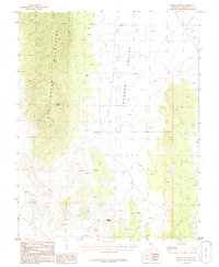
1985 Map of Meeker Peak
USGS Topo · Published 1986About this map
Meeker Peak rises as the dominant landmark of the Worthington Mountains on this mid-1980s topographic survey. The eastern portion of the map is defined by the broad, high-desert expanse of Garden Valley, where unimproved roads and trails trace the edges of the alluvial fans. This landscape reveals a history of prospecting and scarce water management, typical of Lincoln County’s basin and range geography. Evidence of mining activity is preserved in the form of a Prospect located near the base of the mountains, while the remote desert hydrology is represented by Modes Spring and various other Springs tucked into the mountain folds. These features indicate the persistent efforts to locate resources and sustain life in a dry, high-elevation environment before modern infrastructure transformed the region.
Find a feature on this map
6 named features on this map. Tap any name to fly to it.
Don’t see what you’re looking for? This feature index may not catch every label — zoom into the map to look around manually.
Map Details
Editions of this 1985 Meeker Peak Map
This is the sole edition of this map. No revisions or reprints were ever made.
Other maps of this area

1942 · Penoyer Valley
USGS Topo · 1:125,000

1954 · Caliente
USGS Topo · 1:250,000

1959 · Caliente
USGS Topo · 1:250,000

1964 · Tempiute Mtn
USGS Topo · 1:62,500

1985 · Worthington Peak
USGS Topo · 1:24,000

1985 · McCutchen Spring
USGS Topo · 1:24,000
1985 · Mount Irish
USGS Topo · 1:24,000

1985 · Murphy Gap
USGS Topo · 1:24,000

1985 · Worthington Peak SW
USGS Topo · 1:24,000

1985 · Murphy Gap NW
USGS Topo · 1:24,000