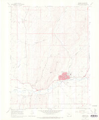
1966 Map of Meeker
USGS Topo · Published 1970About this map
Meeker serves as the focal point of this mid-1960s survey, situated along the northern banks of the White River in the heart of Agency Park. The town layout includes essential civic infrastructure such as the Courthouse, Hospital, and local schools like Jr High Sch and HS. Beyond the town limits, the landscape is defined by the broad river valley of Powell Park and the rugged drainages of Sulphur Creek and Strawberry Creek.
Find a feature on this map
36 named features on this map. Tap any name to fly to it.
Don’t see what you’re looking for? This feature index may not catch every label — zoom into the map to look around manually.
Map Details
Editions of this 1966 Meeker Map
2 editions found
Other maps of this area

1906 · Grand Hogback
USGS Topo · 1:125,000

1907 · White River
USGS Topo · 1:125,000

1910 · Danforth Hills
USGS Topo · 1:125,000

1910 · Grand Hogback
USGS Topo · 1:125,000

1910 · White River
USGS Topo · 1:125,000

1912 · Meeker
USGS Topo · 1:62,500

1914 · Meeker
USGS Topo · 1:62,500

1952 · Segar Mountain
USGS Topo · 1:24,000

1954 · Vernal
USGS Topo · 1:250,000

1954 · Craig
USGS Topo · 1:250,000