1955 Map of Meeks Bay
USGS Topo · Published 1956About this map
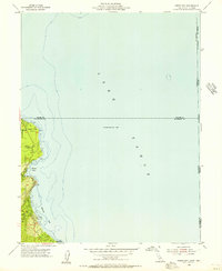
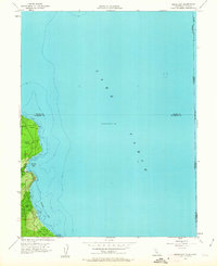
Lake Tahoe dominates this mid-century survey, which focuses on the western shoreline where early lakeside developments began to take root. The settlement of Tahoma and the recreation areas at Meeks Bay sit at the edge of the Eldorado National Forest, illustrating a landscape defined by seasonal residence and conservation. North of Rubicon Bay, the terrain rises toward Sugar Pine Point and drops into Lonely Gulch, showing the steep transition from the water's edge to the high sierra. This 1955 field check reveals the early infrastructure of the region, including the General Guard Station and the beginnings of D L Bliss State Park. The shoreline detail includes underwater bathymetry and specific coastal landmarks like Paradise Flat, providing a clear record of the lakefront before the extensive development of the late 20th century.
Find a feature on this map
22 named features on this map. Tap any name to fly to it.
Don’t see what you’re looking for? This feature index may not catch every label — zoom into the map to look around manually.
Map Details
Editions of this 1955 Meeks Bay Map
3 editions found

Other maps of this area

1889 · Pyramid Peak
USGS Topo · 1:125,000

1889 · Markleeville
USGS Topo · 1:125,000

1891 · Carson
USGS Topo · 1:125,000

1891 · Markleeville
USGS Topo · 1:125,000

1891 · Truckee
USGS Topo · 1:125,000

1891 · Pyramid Peak
USGS Topo · 1:125,000

1893 · Carson
USGS Topo · 1:125,000

1893 · Markleeville
USGS Topo · 1:125,000

1893 · Truckee
USGS Topo · 1:125,000

1895 · Pyramid Peak
USGS Topo · 1:125,000