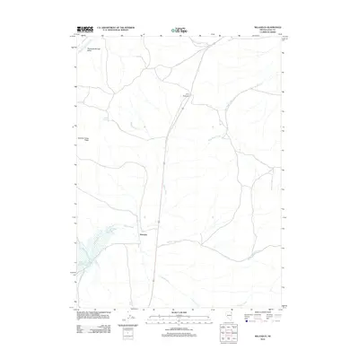
2012 Map of Melandco
USGS Topo · Published 2012About this map
Melandco sits at the heart of this high-desert landscape in Elko County, serving as a focal point where multiple drainage systems converge. The terrain is defined by a network of seasonal and perennial waterways, including the winding paths of Bishop Creek and Willow Creek, which flow toward the Bishop Creek Reservoir in the southwest. This area illustrates the critical importance of water management in the Great Basin, with numerous named water sources like Bishop Spring and Ledge Spring dotted across the arid expanse.
Find a feature on this map
13 named features on this map. Tap any name to fly to it.
Don’t see what you’re looking for? This feature index may not catch every label — zoom into the map to look around manually.
Map Details
Editions of this 2012 Melandco Map
This is the sole edition of this map. No revisions or reprints were ever made.
Other maps of this area

1955 · Wells
USGS Topo · 1:250,000

1958 · Wells
USGS Topo · 1:250,000

1961 · Wells
USGS Topo · 1:250,000

1968 · Wilkins
USGS Topo · 1:24,000

1968 · Holborn
USGS Topo · 1:24,000

1968 · Melandco
USGS Topo · 1:24,000

1968 · Wells Peak
USGS Topo · 1:24,000

1968 · Summer Camp
USGS Topo · 1:24,000
1968 · Oxley Peak
USGS Topo · 1:24,000

1968 · Wine Cup Ranch
USGS Topo · 1:24,000