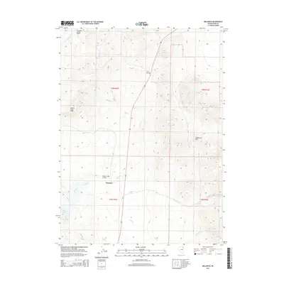
2014 Map of Melandco
USGS Topo · Published 2014About this map
Melandco sits at the heart of this Elko County landscape, where the high desert terrain is defined by a network of seasonal drainages and topographic landmarks. The area is dominated by the Windermere Hills to the east and the prominent H D Summit, which serves as a key navigation point along the modern roadway. This 2014 survey documents the hydrology of the Great Basin, tracing the course of Bishop Cr as it flows toward the Bishop Creek Canyon and the Bishop Cr Reservoir in the southwest corner. The map reveals the vital role of water in this arid environment through numerous named sources such as Bishop Spring, Ledge Spring, and the broad Thousand Springs Valley. From Summer Camp Ridge to the winding paths of Cricket Cr and Willow Cr, the sheet provides a precise look at the land's contours and drainage patterns during the early 21st century.
Find a feature on this map
19 named features on this map. Tap any name to fly to it.
Don’t see what you’re looking for? This feature index may not catch every label — zoom into the map to look around manually.
Map Details
Editions of this 2014 Melandco Map
This is the sole edition of this map. No revisions or reprints were ever made.
Other maps of this area

1955 · Wells
USGS Topo · 1:250,000

1958 · Wells
USGS Topo · 1:250,000

1961 · Wells
USGS Topo · 1:250,000

1968 · Wilkins
USGS Topo · 1:24,000

1968 · Holborn
USGS Topo · 1:24,000

1968 · Melandco
USGS Topo · 1:24,000

1968 · Wells Peak
USGS Topo · 1:24,000

1968 · Summer Camp
USGS Topo · 1:24,000
1968 · Oxley Peak
USGS Topo · 1:24,000

1968 · Wine Cup Ranch
USGS Topo · 1:24,000