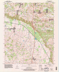
1993 Map of Melber
USGS Topo · Published 1996About this map
The Tennessee Valley Divide snakes through this landscape on the border of McCracken Co and Graves Co, defining the drainage patterns that flow toward the Tennessee and Ohio Rivers. The area is characterized by a high concentration of family and community burial grounds, including the Thompson Cem, Johnson Cem, and Liberty Cem, which offer significant value for genealogical research in this part of western Kentucky. Local commerce and transit are centered around the settlements of Melber, Folsomdale, and Boaz, connected by a network of rural routes like Lovelaceville Florence Station Road.
Find a feature on this map
46 named features on this map. Tap any name to fly to it.
Don’t see what you’re looking for? This feature index may not catch every label — zoom into the map to look around manually.
Map Details
Editions of this 1993 Melber Map
This is the sole edition of this map. No revisions or reprints were ever made.
Other maps of this area

1926 · Paducah
USGS Topo · 1:62,500

1928 · La Center
USGS Topo · 1:62,500

1929 · Paducah
USGS Topo · 1:62,500

1932 · La Center
USGS Topo · 1:62,500

1936 · Melber
USGS Topo · 1:24,000

1936 · Paducah
USGS Topo · 1:24,000

1936 · Symsonia
USGS Topo · 1:24,000

1936 · Westplains
USGS Topo · 1:24,000

1940 · Paducah
USGS Topo · 1:62,500

1949 · Paducah
USGS Topo · 1:250,000