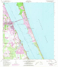
1949 Map of Melbourne East
USGS Topo · Published 1981About this map
The coastal communities of Melbourne and Palm Bay anchor this 1948 topographic survey, which captures the Atlantic coastline prior to the mid-century space-age boom. The landscape is dominated by the Indian River and the Intracoastal Waterway, separating the mainland from the barrier island settlements of Indialantic and Melbourne Beach. Infrastructure of the era is clearly visible, including the Florida East Coast railroad line and the Melbourne Causeway connecting the two landmasses. On the mainland, the Melbourne Regional Airport and the Drive-in Theater suggest the post-war shift toward automobile-centric development. Numerous coastal points such as Castaway Pt and Cape Malabar define the shifting shoreline, while internal drainages like Crane Creek and Turkey Creek feed into the estuary system. Purple revisions from 1980 show the subsequent expansion of urban areas across this Brevard County corridor.
Find a feature on this map
33 named features on this map. Tap any name to fly to it.
Don’t see what you’re looking for? This feature index may not catch every label — zoom into the map to look around manually.
Map Details
Editions of this 1949 Melbourne East Map
5 editions found
Other maps of this area

1949 · Melbourne West
USGS Topo · 1:24,000

1949 · Melbourne East
USGS Topo · 1:24,000

1949 · Sebastian NW
USGS Topo · 1:24,000

1949 · Eau Gallie
USGS Topo · 1:24,000

1949 · Grant
USGS Topo · 1:24,000

1949 · Tropic
USGS Topo · 1:24,000

1951 · Sebastian NW
USGS Topo · 1:24,000

1951 · Melbourne East
USGS Topo · 1:24,000

1951 · Eau Gallie
USGS Topo · 1:24,000

1951 · Melbourne West
USGS Topo · 1:24,000