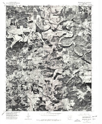
1976 Map of Melbourne NE
USGS Topo · Published 1977About this map
Strawberry River meanders across the northern portion of this 1976 orthophotoquad, defining a landscape where the tight bends of the watercourse contrast with the developing road networks of north-central Arkansas. Unlike a traditional line-drawn topographic map, this aerial perspective reveals the literal footprint of the land, showing the exact configuration of wooded hillsides and cleared agricultural fields near Wiseman and Franklin. The southeastern corner of the quadrangle shows a dense, modern subdivision layout that stands in stark contrast to the scattered homesteads around Violet Hill. For those studying the evolution of Izard County, this document provides a rare visual bridge between the traditional rural settlement patterns and the emerging residential developments of the mid-1970s.
Find a feature on this map
4 named features on this map. Tap any name to fly to it.
Don’t see what you’re looking for? This feature index may not catch every label — zoom into the map to look around manually.
Map Details
Editions of this 1976 Melbourne NE Map
This is the sole edition of this map. No revisions or reprints were ever made.
Other maps of this area

1950 · Salem
USGS Topo · 1:62,500

1951 · Salem
USGS Topo · 1:62,500

1951 · Melbourne
USGS Topo · 1:62,500

1957 · Poplar Bluff
USGS Topo · 1:250,000

1959 · Poplar Bluff
USGS Topo · 1:250,000

1960 · Poplar Bluff
USGS Topo · 1:250,000
1962 · Sidney
USGS Topo · 1:24,000

1962 · Myron
USGS Topo · 1:24,000

1962 · Agnos
USGS Topo · 1:24,000
1976 · Salem SW
USGS Topo · 1:24,000