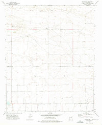
1973 Map of Melrose SE
USGS Topo · Published 1976About this map
Spencer Ranch and Smart Ranch characterize the sparse, ranching-driven landscape of the high plains along the border of Curry and Roosevelt counties in the early 1970s. The terrain is marked by a wide distribution of wells, essential for livestock and agriculture in this arid region, and a local Gravel Pit near the southern boundary. Surveyed by photogrammetric methods in 1972 and field checked in 1973, the map shows a network of section lines and gravel roads, including Sun Dale Valley Rd, that connect isolated holdings. The placement of the Base Line across the southern portion of the quadrangle highlights the systematic rectangular survey structure that defined land ownership and navigation in Eastern New Mexico during this era.
Find a feature on this map
9 named features on this map. Tap any name to fly to it.
Don’t see what you’re looking for? This feature index may not catch every label — zoom into the map to look around manually.
Map Details
Editions of this 1973 Melrose SE Map
2 editions found
Other maps of this area

1954 · Clovis
USGS Topo · 1:250,000

1957 · Portair
USGS Topo · 1:62,500

1957 · Melrose
USGS Topo · 1:62,500

1957 · Portales
USGS Topo · 1:62,500

1958 · Clovis
USGS Topo · 1:250,000

1972 · Melrose East
USGS Topo · 1:24,000

1973 · Floyd
USGS Topo · 1:24,000

1973 · Melrose West
USGS Topo · 1:24,000

1973 · Tule Lake
USGS Topo · 1:24,000

1973 · Upton
USGS Topo · 1:24,000