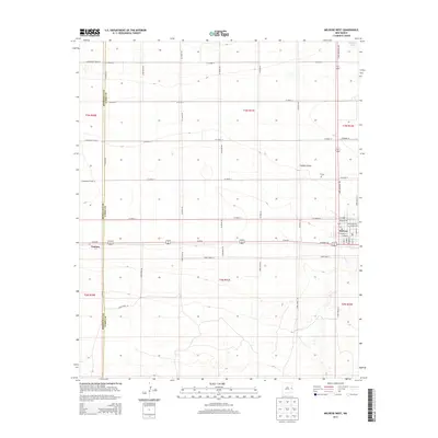
2013 Map of Melrose West
USGS Topo · Published 2013About this map
Melrose serves as the primary hub of activity on this High Plains landscape, situated at the intersection of State Highway 268 and the major transport corridor of Us-60 84. The town's grid is meticulously detailed, showing residential streets such as Missouri Ave and Wisconsin Ave surrounding the central Po. To the west, the settlement of Cantara sits directly on the county line separating Roosevelt and Curry Counties, marking a distinct point along the railway and highway route. The surrounding terrain is defined by wide open expanses and seasonal water features like Brooks Lake in the northeast corner and the winding path of Fiddlers Draw. Rural life is evidenced by the systematic grid of section roads, including Co Road 16 and Curry Road AO, which provide access to the outlying lands and the N Cem north of the main township.
Find a feature on this map
48 named features on this map. Tap any name to fly to it.
Don’t see what you’re looking for? This feature index may not catch every label — zoom into the map to look around manually.
Map Details
Editions of this 2013 Melrose West Map
This is the sole edition of this map. No revisions or reprints were ever made.
Other maps of this area

1954 · Clovis
USGS Topo · 1:250,000

1957 · Melrose
USGS Topo · 1:62,500

1958 · Clovis
USGS Topo · 1:250,000

1972 · Melrose East
USGS Topo · 1:24,000

1973 · Krider
USGS Topo · 1:24,000

1973 · Field SE
USGS Topo · 1:24,000

1973 · Melrose West
USGS Topo · 1:24,000

1973 · Tule Lake
USGS Topo · 1:24,000

1973 · Field SW
USGS Topo · 1:24,000
1973 · House SE
USGS Topo · 1:24,000