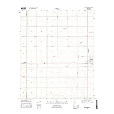
2017 Map of Melrose West
USGS Topo · Published 2017About this map
Melrose serves as the primary hub of activity in this High Plains region, shown with its grid of streets including N Main St and W Denby Ave. The settlement's essential services are anchored by the local Po, while the nearby North Cem offers a focal point for genealogical research. To the west, the tiny rail-aligned siding of Cantara sits along the section lines that define the agricultural layout of the county. The landscape is characterized by its expansive horizontal drainage patterns, most notably Fiddlers Draw and the isolated depression of Brooks Lake in the far northeast corner. This map illustrates the intersection of Curry and Roosevelt counties, specifically along Co Line Rd, highlighting how township and range boundaries dictated the placement of the region’s rectilinear road network, from Curry Road 12 to the more distant N Roosevelt Rd 16.
Find a feature on this map
47 named features on this map. Tap any name to fly to it.
Don’t see what you’re looking for? This feature index may not catch every label — zoom into the map to look around manually.
Map Details
Editions of this 2017 Melrose West Map
This is the sole edition of this map. No revisions or reprints were ever made.
Other maps of this area

1954 · Clovis
USGS Topo · 1:250,000

1957 · Melrose
USGS Topo · 1:62,500

1958 · Clovis
USGS Topo · 1:250,000

1972 · Melrose East
USGS Topo · 1:24,000

1973 · Krider
USGS Topo · 1:24,000

1973 · Field SE
USGS Topo · 1:24,000

1973 · Melrose West
USGS Topo · 1:24,000

1973 · Tule Lake
USGS Topo · 1:24,000

1973 · Field SW
USGS Topo · 1:24,000
1973 · House SE
USGS Topo · 1:24,000