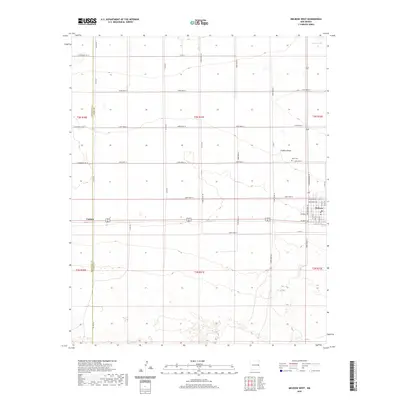
2020 Map of Melrose West
USGS Topo · Published 2020About this map
Melrose serves as the primary hub of this eastern New Mexico landscape, situated at a junction where local streets like Missouri Ave and Wisconsin Ave meet the regional transport corridors. The town's grid is detailed down to residential streets such as N Brownhorn St and N 1st St, providing a clear view of the village's footprint. Just outside the main settlement, the North Cem offers a point of interest for genealogists tracing local families. The surrounding terrain is defined by the high plains, where the wide basin of Fiddlers Draw cuts through the landscape. To the west lies the smaller settlement of Cantara, while the sparse northern reaches are marked by Brooks Lake. The map illustrates a disciplined grid of rural roads, including Curry Road 15 and Co RD An, reflecting the region's agricultural organization.
Find a feature on this map
44 named features on this map. Tap any name to fly to it.
Don’t see what you’re looking for? This feature index may not catch every label — zoom into the map to look around manually.
Map Details
Editions of this 2020 Melrose West Map
This is the sole edition of this map. No revisions or reprints were ever made.
Other maps of this area

1954 · Clovis
USGS Topo · 1:250,000

1957 · Melrose
USGS Topo · 1:62,500

1958 · Clovis
USGS Topo · 1:250,000

1972 · Melrose East
USGS Topo · 1:24,000

1973 · Krider
USGS Topo · 1:24,000

1973 · Field SE
USGS Topo · 1:24,000

1973 · Melrose West
USGS Topo · 1:24,000

1973 · Tule Lake
USGS Topo · 1:24,000

1973 · Field SW
USGS Topo · 1:24,000
1973 · House SE
USGS Topo · 1:24,000