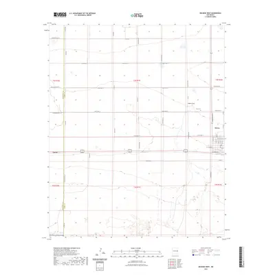
2023 Map of Melrose West
USGS Topo · Published 2023About this map
Melrose serves as the primary hub in this portion of the Llano Estacado, where a grid of rural roads meets the residential streets of the town center. The landscape is defined by the section lines of the Public Land Survey System, with large-scale agricultural blocks partitioned by routes such as Curry Road 12 and Curry Road Am. Near the western edge of the town site, North Cem provides a point of genealogical interest, while the natural drainage of Fiddlers Draw cuts across the northern plains. The boundary between Roosevelt Co and Curry Co runs vertically along Co Line Rd, marking the transition between these two High Plains jurisdictions. To the west, the settlement of Cantara sits along the highway corridor, illustrating the linear development typical of this semi-arid region where transportation and water are the primary drivers of settlement patterns.
Find a feature on this map
45 named features on this map. Tap any name to fly to it.
Don’t see what you’re looking for? This feature index may not catch every label — zoom into the map to look around manually.
Map Details
Editions of this 2023 Melrose West Map
This is the sole edition of this map. No revisions or reprints were ever made.
Other maps of this area

1954 · Clovis
USGS Topo · 1:250,000

1957 · Melrose
USGS Topo · 1:62,500

1958 · Clovis
USGS Topo · 1:250,000

1972 · Melrose East
USGS Topo · 1:24,000

1973 · Krider
USGS Topo · 1:24,000

1973 · Field SE
USGS Topo · 1:24,000

1973 · Melrose West
USGS Topo · 1:24,000

1973 · Tule Lake
USGS Topo · 1:24,000

1973 · Field SW
USGS Topo · 1:24,000
1973 · House SE
USGS Topo · 1:24,000