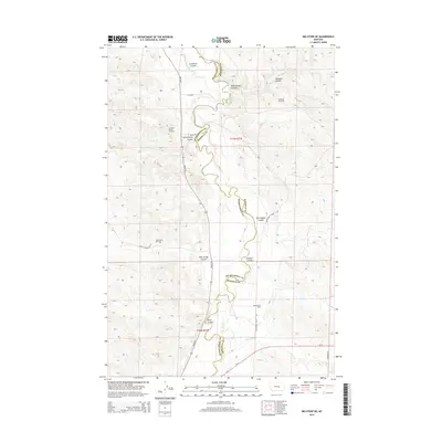
2014 Map of Melstone NE
USGS Topo · Published 2014About this map
The Musselshell River carves a winding path through the borderlands of Musselshell and Rosebud counties, defining a landscape marked by deep coulees and energy extraction. Extensive oil development is evident across the territory, with the Stensvad Oil Field, Ivanhoe Dome Oil Field, and Keg Coulee Oil Field peppering the plains north of the river, while the Bascom Oil Field occupies the southeastern corner. Irrigation and water management are central to the local geography, seen in the path of the Delphia Melstone Ditch and its proximity to Gremmert Coulee. The topography is a complex network of seasonal drainage basins including Seventynine Coulee, Orchard Coulee, and Butts Coulee. Transportation follows the river valley and high ridges, anchored by Mosby Rd, Musselshell River Rd, and the southern corridor of Us-12, showing the modern infrastructure required to service the region's scattered oil operations and ranch lands.
Find a feature on this map
25 named features on this map. Tap any name to fly to it.
Don’t see what you’re looking for? This feature index may not catch every label — zoom into the map to look around manually.
Map Details
Editions of this 2014 Melstone NE Map
This is the sole edition of this map. No revisions or reprints were ever made.
Other maps of this area

1954 · Forsyth
USGS Topo · 1:250,000

1957 · Forsyth
USGS Topo · 1:250,000

1958 · Forsyth
USGS Topo · 1:250,000

1962 · Queens Point
USGS Topo · 1:24,000

1962 · Guthridge Ranch
USGS Topo · 1:24,000

1962 · Melstone NE
USGS Topo · 1:24,000

1962 · Maxwell Ranch
USGS Topo · 1:24,000

1962 · Melstone NW
USGS Topo · 1:24,000

1962 · Kincheloe Ranch
USGS Topo · 1:24,000

1962 · Mosby SE
USGS Topo · 1:24,000