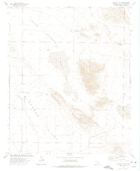
1972 Map of Melville Lake
USGS Topo · Published 1975About this map
Upper Johnson Valley dominates this high-desert landscape in San Bernardino County, captured here as it appeared in the early 1970s. The map illustrates a remote environment defined by ephemeral water features and sparse human outposts, notably the Shehorn Ranch and the small settlement of Armelino along Armelino Ave. The presence of a Landing Strip and numerous Jeep Trails suggest a reliance on specialized transportation to navigate the arid expanse between Melville Lake and Means Lake. Geologic interest is found in the Sand Dunes and various Prospects scattered near the Quarry, indicating mineral exploration typical of the region. Local infrastructure is represented by desert thoroughfares like Boone Road and Cole Rd, connecting isolated wells such as Means Well to the broader Mojave network.
Find a feature on this map
21 named features on this map. Tap any name to fly to it.
Don’t see what you’re looking for? This feature index may not catch every label — zoom into the map to look around manually.
Map Details
Editions of this 1972 Melville Lake Map
3 editions found
Other maps of this area

1901 · Southern California Sheet No. 1
USGS Topo · 1:250,000

1902 · San Gorgonio
USGS Topo · 1:125,000

1904 · Southern California Sheet No. 1
USGS Topo · 1:250,000

1953 · San Bernardino
USGS Topo · 1:250,000

1954 · Galway Lake
USGS Topo · 1:24,000

1954 · Emerson Lake
USGS Topo · 1:24,000

1955 · Old Woman Springs
USGS Topo · 1:62,500

1955 · Lavic
USGS Topo · 1:62,500

1955 · Emerson Lake
USGS Topo · 1:62,500

1955 · Rodman Mountains
USGS Topo · 1:62,500