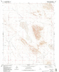
1972 Map of Melville Lake
USGS Topo · Published 1994About this map
Upper Johnson Valley and the broader Johnson Valley floor dominate this desert landscape, where water access dictated the placement of early improvements. Isolated outposts like Shehorn Ranch and scattered water sources such as Means Well, Dry Well, and other unnamed wells show the reliance on groundwater in this arid basin. The presence of a Landing Strip and a network of desert tracks, including Pony Road and Barnes Road, reflects the area's mid-century utility for transportation and recreation.
Find a feature on this map
49 named features on this map. Tap any name to fly to it.
Don’t see what you’re looking for? This feature index may not catch every label — zoom into the map to look around manually.
Map Details
Editions of this 1972 Melville Lake Map
3 editions found
Other maps of this area

1901 · Southern California Sheet No. 1
USGS Topo · 1:250,000

1902 · San Gorgonio
USGS Topo · 1:125,000

1904 · Southern California Sheet No. 1
USGS Topo · 1:250,000

1953 · San Bernardino
USGS Topo · 1:250,000

1954 · Galway Lake
USGS Topo · 1:24,000

1954 · Emerson Lake
USGS Topo · 1:24,000

1955 · Old Woman Springs
USGS Topo · 1:62,500

1955 · Lavic
USGS Topo · 1:62,500

1955 · Emerson Lake
USGS Topo · 1:62,500

1955 · Rodman Mountains
USGS Topo · 1:62,500