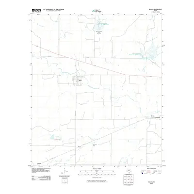
2010 Map of Melvin
USGS Topo · Published 2010About this map
Melvin serves as the central hub of this agricultural landscape in McCulloch County, positioned where regional routes like Ranch Rd 2028 and several county roads converge. The settlement pattern is defined by its relationship to the water, with the town situated just south of the winding Brady Creek. To the west, the Melvin Cemetery stands as a focal point for local genealogy, while smaller rural nodes such as Marco, Whiteland, and Homer Junction dot the surrounding countryside.
Find a feature on this map
40 named features on this map. Tap any name to fly to it.
Don’t see what you’re looking for? This feature index may not catch every label — zoom into the map to look around manually.
Map Details
Editions of this 2010 Melvin Map
This is the sole edition of this map. No revisions or reprints were ever made.
Other maps of this area

1892 · Eden
USGS Topo · 1:125,000

1894 · Brady
USGS Topo · 1:125,000

1896 · Eden
USGS Topo · 1:125,000

1928 · Waldrip
USGS Topo · 1:62,500

1931 · Stacy
USGS Topo · 1:62,500

1954 · Brownwood
USGS Topo · 1:250,000

1960 · West Sweden
USGS Topo · 1:24,000

1960 · Melvin
USGS Topo · 1:24,000

1963 · Brady SW
USGS Topo · 1:24,000
1967 · Salt Gap
USGS Topo · 1:24,000