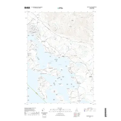
2021 Map of Melvin Village
USGS Topo · Published 2021About this map
The northeastern reaches of Lake Winnipesaukee dominate this landscape, where the waters of Melvin Bay and Moultonborough Bay meet a complex shoreline of points and islands. The settlement of Melvin Village serves as a focal point along the coast, situated where the Melvin River enters the lake. Further south, the map details the waterfront communities of Wawbeek and Union Wharf, while Center Tuftonboro sits slightly inland, marked by the Town Hall Cem. To the north, the terrain rises sharply into the Ossipee Mountains, featuring prominent peaks such as Mt Shaw and Bald Knob. This contrast between the island-dotted waters of Winnipesaukee and the high elevation of the northern range highlights the unique geography of this Belknap and Carroll County border region. Local history is preserved in small burial grounds like Bodge Cem and Edgerly Cem, alongside newer developments such as the alpine-inspired street names of Suissevale.
Find a feature on this map
178 named features on this map. Tap any name to fly to it.
Don’t see what you’re looking for? This feature index may not catch every label — zoom into the map to look around manually.
Map Details
Editions of this 2021 Melvin Village Map
This is the sole edition of this map. No revisions or reprints were ever made.
Other maps of this area

1909 · Winnepesaukee
USGS Topo · 1:62,500

1928 · Wolfeboro
USGS Topo · 1:62,500

1930 · Ossipee Lake
USGS Topo · 1:62,500

1931 · Mt. Chocorua
USGS Topo · 1:62,500

1949 · Portland
USGS Topo · 1:250,000

1956 · Winnipesaukee
USGS Topo · 1:62,500

1956 · Portland
USGS Topo · 1:250,000

1958 · Ossipee Lake
USGS Topo · 1:62,500

1958 · Wolfeboro
USGS Topo · 1:62,500

1958 · Mt. Chocorua
USGS Topo · 1:62,500