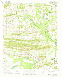
1961 Map of Menifee
USGS Topo · Published 1973About this map
Menifee serves as a central hub on this map, situated where the Missouri Pacific railroad corridor and Route 64 parallel the low-lying terrain near Tank Lake. The landscape is defined by the winding course of Cadron Creek, which forms the boundary between Conway and Faulkner counties, and a series of smaller waterways like Cypress Creek and Caney Creek. This 1961 survey provides a clear view of rural community infrastructure, showing several churches such as Mt Hebrew Ch and Pilgrim Rest Ch, alongside educational landmarks like the County Training Sch. The terrain rises toward Ragsdale Mtn in the northwest, while the southern section is dominated by the meandering Miller Bayou and Old River Lake, illustrating the hydrological transition from upland ridges to bottomland basins typical of this part of Arkansas.
Find a feature on this map
36 named features on this map. Tap any name to fly to it.
Don’t see what you’re looking for? This feature index may not catch every label — zoom into the map to look around manually.
Map Details
Editions of this 1961 Menifee Map
3 editions found
Other maps of this area

1892 · Morrillton
USGS Topo · 1:125,000

1894 · Morrillton
USGS Topo · 1:125,000

1956 · Russellville
USGS Topo · 1:250,000

1961 · Menifee
USGS Topo · 1:24,000

1961 · Morrilton East
USGS Topo · 1:24,000

1961 · Houston
USGS Topo · 1:24,000

1961 · Gleason
USGS Topo · 1:24,000

1961 · Conway
USGS Topo · 1:24,000

1961 · Conway
USGS Topo · 1:62,500

1961 · Bee Branch
USGS Topo · 1:62,500