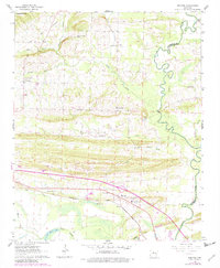
1961 Map of Menifee
USGS Topo · Published 1982About this map
Menifee sits at the heart of this Arkansas landscape, where the Missouri Pacific railroad cuts a straight path across the southern terrain. This 1961 survey, updated with revisions through the early 1980s, reveals a community deeply rooted in its local institutions, from the County Training Sch and Union Chapel Sch to numerous rural sanctuaries like Zion Temple and Mt Hebrew Ch. The map illustrates the transition from the winding oxbows of Old River Lake and the Cadron Creek bottomlands to the rising elevations of Ragsdale Mtn. This topographic record highlights how transport and water influenced settlement patterns, showing clusters of development near Gap Creek and Cypress Creek, while industrial activity is noted at the Shale Pit and southern Quarry.
Find a feature on this map
29 named features on this map. Tap any name to fly to it.
Don’t see what you’re looking for? This feature index may not catch every label — zoom into the map to look around manually.
Map Details
Editions of this 1961 Menifee Map
3 editions found
Other maps of this area

1892 · Morrillton
USGS Topo · 1:125,000

1894 · Morrillton
USGS Topo · 1:125,000

1956 · Russellville
USGS Topo · 1:250,000

1961 · Menifee
USGS Topo · 1:24,000

1961 · Morrilton East
USGS Topo · 1:24,000

1961 · Houston
USGS Topo · 1:24,000

1961 · Gleason
USGS Topo · 1:24,000

1961 · Conway
USGS Topo · 1:24,000

1961 · Conway
USGS Topo · 1:62,500

1961 · Bee Branch
USGS Topo · 1:62,500