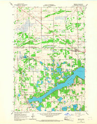
1966 Map of Mentor
USGS Topo · Published 1967About this map
Maple Lake dominates the southern landscape of this 1960s survey, surrounded by the townships of Godfrey, Woodside, and Grove Park. The village of Mentor sits as a central hub at the junction of the Great Northern railroad and several county ditches, reflecting the region's managed hydrology and rail-dependent transit. Further south, the settlement of Maple Bay rests near the lake's western edge, a site marked by numerous Gravel Pits and local landmarks like the Townhall. This map provides a detailed view of the area's rural cemetery network, including Faith Cem, St Lawrence Cem, and Rosehill Cem. To the northwest, the Tilden State Wildlife Management Area and Bakken Lake show the preservation of wetland habitats alongside an Old Railroad Grade that speaks to the shifting infrastructure of northwestern Minnesota.
Find a feature on this map
35 named features on this map. Tap any name to fly to it.
Don’t see what you’re looking for? This feature index may not catch every label — zoom into the map to look around manually.
Map Details
Editions of this 1966 Mentor Map
This is the sole edition of this map. No revisions or reprints were ever made.
Other maps of this area

1918 · Terrebonne
USGS Topo · 1:62,500

1918 · Red Lake Falls
USGS Topo · 1:62,500

1919 · Valley
USGS Topo · 1:62,500

1952 · Red Lake Falls
USGS Topo · 1:62,500

1952 · Grand Forks
USGS Topo · 1:250,000

1956 · Grand Forks
USGS Topo · 1:250,000

1964 · Terrebonne
USGS Topo · 1:24,000

1964 · Brooks
USGS Topo · 1:24,000

1965 · Dugdale
USGS Topo · 1:24,000

1965 · Fertile
USGS Topo · 1:24,000