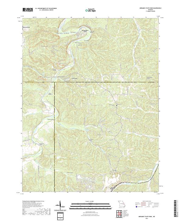
The Meramec River winds through a landscape defined by dramatic karst features and spring-fed tributaries along the borders of Franklin, Crawford, and Washington counties. In this Ozark river corridor, significant water sources like La Jolla Spring, Pratt Spring, and Hamilton Spring emerge from the limestone terrain. The map details the transition from the edge of Sullivan into the dense topographic network of Meramec State Park, where hiking paths like the Wilderness Trl and Natural Wonders Trl follow the high ridges. These upland areas are deeply dissected by numerous named drainages including Sheep Ranch Hollow and Primrose Hollow. Near the center, the small settlement of Caseyville sits at a crossroads, while to the south, Pea Ridge overlooks the surrounding valleys near the Pea Ridge Cem. The crossing at Sappington Bridge serves as a key landmark for navigating the river's path through the county lines.
95 named features on this map. Tap any name to fly to it.
Don’t see what you’re looking for? This feature index may not catch every label — zoom into the map to look around manually.
This is the sole edition of this map. No revisions or reprints were ever made.
71 maps found

1934 Meramec State Park
Washington County, MO

1937 Meramec State Park
Washington County, MO

1937 Tiff
Washington County, MO

1939 Tiff
Washington County, MO

1946 Richwoods
Washington County, MO

1948 Richwoods
Washington County, MO

1958 Belgrade
Washington County, MO

1958 Palmer
Washington County, MO

1958 Shirley
Washington County, MO

1969 Anthonies Mill
Washington County, MO

1969 Meramec State Park
Washington County, MO

1978 Berryman
Washington County, MO

1978 Courtois
Washington County, MO

1981 Cyclone Hollow
Washington County, MO

1981 Ebo
Washington County, MO

1981 Old Mines
Washington County, MO

1981 Richwoods
Washington County, MO

1981 Tiff
Washington County, MO

1999 Berryman
Washington County, MO

1999 Courtois
Washington County, MO

1999 Palmer
Washington County, MO

1999 Shirley
Washington County, MO
2011 Belgrade
Washington County, MO
2011 Berryman
Washington County, MO
2011 Courtois
Washington County, MO
2011 Palmer
Washington County, MO
2011 Shirley
Washington County, MO
2012 Anthonies Mill
Washington County, MO
2012 Cyclone Hollow
Washington County, MO
2012 Ebo
Washington County, MO
2012 Meramec State Park
Washington County, MO
2012 Old Mines
Washington County, MO
2012 Richwoods
Washington County, MO
2012 Tiff
Washington County, MO
2015 Anthonies Mill
Washington County, MO
2015 Belgrade
Washington County, MO
2015 Berryman
Washington County, MO
2015 Courtois
Washington County, MO
2015 Cyclone Hollow
Washington County, MO
2015 Ebo
Washington County, MO
2015 Meramec State Park
Washington County, MO
2015 Old Mines
Washington County, MO
2015 Palmer
Washington County, MO
2015 Richwoods
Washington County, MO
2015 Shirley
Washington County, MO
2015 Tiff
Washington County, MO
2017 Anthonies Mill
Washington County, MO
2017 Belgrade
Washington County, MO
2017 Berryman
Washington County, MO
2017 Courtois
Washington County, MO
2017 Cyclone Hollow
Washington County, MO
2017 Ebo
Washington County, MO
2017 Meramec State Park
Washington County, MO
2017 Old Mines
Washington County, MO
2017 Palmer
Washington County, MO
2017 Richwoods
Washington County, MO
2017 Shirley
Washington County, MO
2017 Tiff
Washington County, MO

2021 Anthonies Mill
Washington County, MO

2021 Belgrade
Washington County, MO

2021 Berryman
Washington County, MO

2021 Courtois
Washington County, MO

2021 Cyclone Hollow
Washington County, MO
2021 Ebo
Washington County, MO

2021 Meramec State Park
Washington County, MO

2021 Old Mines
Washington County, MO

2021 Palmer
Washington County, MO

2021 Richwoods
Washington County, MO

2021 Shirley
Washington County, MO

2021 Tiff
Washington County, MO

2023 Ebo
Washington County, MO









