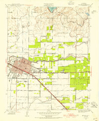
1946 Map of Merced
USGS Topo · Published 1954About this map
Merced serves as the hub of this 1940s landscape, where the established town grid meets the expanding agricultural infrastructure of the San Joaquin Valley. The city's growth is anchored by healthcare and public institutions, including Mercy Hospital, Merced General Hospital, and the local Fairgrounds. Beyond the urban center, a complex network of irrigation canals like the Fairfield Canal and natural waterways such as Bear Creek and Black Rascal Creek support the surrounding farms. The era's transportation reliance is evident in the dual rail presence of the Southern Pacific and the Atchison Topeka and Santa Fe railroads, which facilitated the movement of goods from outlying settlements like Kadota and Tuttle. Local education is well-distributed through several rural schoolhouses, including Merced Colony Sch, Farmdale Sch, and Tuttle Sch, which provided anchors for their respective farming communities.
Find a feature on this map
33 named features on this map. Tap any name to fly to it.
Don’t see what you’re looking for? This feature index may not catch every label — zoom into the map to look around manually.
Map Details
Editions of this 1946 Merced Map
This is the sole edition of this map. No revisions or reprints were ever made.
Other maps of this area

1914 · Merced
USGS Topo · 1:31,680

1916 · Hopeton
USGS Topo · 1:31,680

1917 · Winton
USGS Topo · 1:31,680

1917 · Merced
USGS Topo · 1:31,680

1918 · Lingard
USGS Topo · 1:31,680

1918 · Atwater
USGS Topo · 1:31,680

1918 · Sandy Mush
USGS Topo · 1:31,680

1918 · Planada
USGS Topo · 1:31,680

1919 · Haystack Mountain
USGS Topo · 1:31,680

1919 · Plainsberg
USGS Topo · 1:31,680