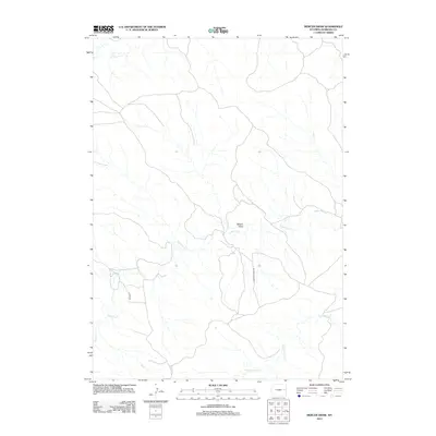
2012 Map of Mercer Draw
USGS Topo · Published 2012About this map
Mercer Draw characterizes this stretch of the Wyoming high plains, where a network of ephemeral drainage systems carves through the Niobrara County landscape. The geography is defined by the convergence of several major creek beds, including the wide path of Lightning Cr and its tributaries such as Twentymile Cr and Walker Cr. This area remains largely open rangeland, with its human presence marked primarily by utility and access corridors like Lightning Creek Rd and K Field Rd. The map illustrates the specialized hydrological patterns of the western Great Plains, where water courses like Little Cow Cr dictate the layout of local ranch roads and land use. The absence of concentrated settlements highlights the sparse, rural nature of this portion of Wyoming in the early 21st century.
Find a feature on this map
7 named features on this map. Tap any name to fly to it.
Don’t see what you’re looking for? This feature index may not catch every label — zoom into the map to look around manually.
Map Details
Editions of this 2012 Mercer Draw Map
This is the sole edition of this map. No revisions or reprints were ever made.
Other maps of this area

1955 · Newcastle
USGS Topo · 1:250,000

1958 · Newcastle
USGS Topo · 1:250,000

1981 · Calf Draw
USGS Topo · 1:24,000

1981 · Mercer Draw
USGS Topo · 1:24,000

1981 · Pinnacle Rocks
USGS Topo · 1:24,000

1981 · Dixon Ranch
USGS Topo · 1:24,000

1981 · Lance Creek NW
USGS Topo · 1:24,000
1981 · Split Hill SW
USGS Topo · 1:24,000
1981 · Lance Creek
USGS Topo · 1:24,000
1981 · Mikes Draw
USGS Topo · 1:24,000