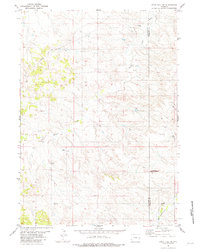
1981 Map of Split Hill SW
USGS Topo · Published 1981About this map
Walker Creek meanders across the high plains of East-Central Wyoming in this early 1980s topographical record. The landscape is defined by its industrial energy infrastructure, straddling the boundary of Converse Co and Niobrara Co. Scattered across the drainage basins of the creek and Twentymile Creek are numerous extraction sites, including a Well Oil Well and several Oil Well locations alongside a Pumping Sta.
Find a feature on this map
10 named features on this map. Tap any name to fly to it.
Don’t see what you’re looking for? This feature index may not catch every label — zoom into the map to look around manually.
Map Details
Editions of this 1981 Split Hill SW Map
This is the sole edition of this map. No revisions or reprints were ever made.
Other maps of this area

1954 · Torrington
USGS Topo · 1:250,000

1955 · Newcastle
USGS Topo · 1:250,000

1958 · Torrington
USGS Topo · 1:250,000

1958 · Newcastle
USGS Topo · 1:250,000

1970 · Bill 4 SE
USGS Topo · 1:24,000

1970 · Walker Creek School
USGS Topo · 1:24,000

1970 · Lost Springs NW
USGS Topo · 1:24,000

1970 · Bill 4 NE
USGS Topo · 1:24,000

1970 · Cooley Draw
USGS Topo · 1:24,000

1979 · Bill
USGS Topo · 1:100,000