
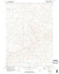
1970 Map of Bill 4 NE
USGS Topo · Published 1973About this map
Sheep ranching and sparse seasonal watercourses define this high plains landscape in Converse County. The presence of the Williams Shearing Pens in the northwest and the Downs Ranch to the south illustrates the specialized agricultural infrastructure required in this arid region during the late 1960s. These locations, alongside the Old Kelly Place, serve as critical markers for genealogists and local historians tracing the grazing history and homesteading patterns of the area.
Find a feature on this map
13 named features on this map. Tap any name to fly to it.
Don’t see what you’re looking for? This feature index may not catch every label — zoom into the map to look around manually.
Map Details
Editions of this 1970 Bill 4 NE Map
2 editions found
Other maps of this area

1955 · Newcastle
USGS Topo · 1:250,000

1958 · Newcastle
USGS Topo · 1:250,000

1970 · Bill 4 SE
USGS Topo · 1:24,000

1970 · Bill 4 NW
USGS Topo · 1:24,000
1970 · Bill 4 SW
USGS Topo · 1:24,000

1971 · Esau Spring
USGS Topo · 1:24,000

1971 · Tin Can Lake
USGS Topo · 1:24,000

1979 · Bill
USGS Topo · 1:100,000

1981 · Pinnacle Rocks
USGS Topo · 1:24,000
1981 · Split Hill SW
USGS Topo · 1:24,000