
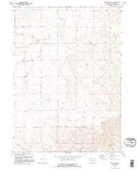
1970 Map of Bill 4 NW
USGS Topo · Published 1973About this map
Dry Creek meanders through this portion of northern Converse County, defining a landscape shaped by intermittent drainage systems in a region dominated by ranching and open range. Surveyed in 1969, the map reveals a series of prominent draws including Sheldon Draw, Reeves Draw, and Eton Draw, which serve as the primary topographic markers across the undulating terrain. Named elevations such as Bower and Esau provide specific points of reference for local land management and navigation. The spatial distribution of these features, along with Mikes Draw in the south, illustrates the critical importance of water flow patterns and high-ground markers in the high plains of Wyoming during the early 1970s.
Find a feature on this map
9 named features on this map. Tap any name to fly to it.
Don’t see what you’re looking for? This feature index may not catch every label — zoom into the map to look around manually.
Map Details
Editions of this 1970 Bill 4 NW Map
2 editions found
Other maps of this area

1955 · Newcastle
USGS Topo · 1:250,000

1958 · Newcastle
USGS Topo · 1:250,000

1959 · Bill
USGS Topo · 1:62,500

1959 · Betty Reservoir
USGS Topo · 1:62,500

1970 · Bill 4 SE
USGS Topo · 1:24,000
1970 · Bill 4 SW
USGS Topo · 1:24,000

1970 · Bill 4 NE
USGS Topo · 1:24,000

1971 · Esau Spring
USGS Topo · 1:24,000

1971 · Tin Can Lake
USGS Topo · 1:24,000

1979 · Bill
USGS Topo · 1:100,000