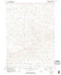
1970 Map of Colter Draw
USGS Topo · Published 1995About this map
Williams Shearing Pens and the Old Kelly Place anchor this 1970 landscape in the high plains of Converse County. The map reveals a ranching and resource-extraction economy, marked by isolated outposts and a Drill Hole alongside the Downs Ranch. The drainage pattern is complex, defined by seasonal watercourses like Horse Creek, Bobcat Creek, and the namesake Colter Draw. This survey captures a specific era of land use where fine red dashed fence lines crisscross the territory, indicating property divisions and grazing management during the late twentieth century. It is a sparsely populated area where survival and industry depend heavily on the proximity to water sources such as Deer Creek and Little Rat Creek.
Find a feature on this map
11 named features on this map. Tap any name to fly to it.
Don’t see what you’re looking for? This feature index may not catch every label — zoom into the map to look around manually.
Map Details
Editions of this 1970 Colter Draw Map
2 editions found
Other maps of this area

1955 · Newcastle
USGS Topo · 1:250,000

1958 · Newcastle
USGS Topo · 1:250,000

1970 · Bill 4 SE
USGS Topo · 1:24,000

1970 · Bill 4 NW
USGS Topo · 1:24,000
1970 · Bill 4 SW
USGS Topo · 1:24,000

1970 · Bill 4 NE
USGS Topo · 1:24,000

1971 · Esau Spring
USGS Topo · 1:24,000

1971 · Tin Can Lake
USGS Topo · 1:24,000

1979 · Bill
USGS Topo · 1:100,000

1981 · Pinnacle Rocks
USGS Topo · 1:24,000