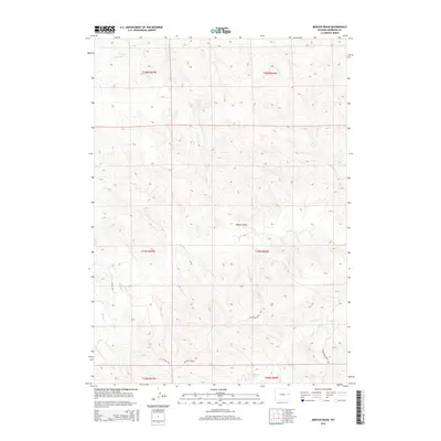
2015 Map of Mercer Draw
USGS Topo · Published 2015About this map
Mercer Draw centers this 2015 survey of the High Plains landscape in Niobrara County, defined by a network of drainage systems that shape the local topography. The hydrological pattern is anchored by the southeastward flow of Lightning Cr and Twentymile Cr, while Little Cow Cr and Walker Cr cut through the northern and western sections. Human activity is sparse and focused on utility and access, evidenced by the presence of K-Field Rd and Lightning Creek Rd. These routes, alongside the established Public Land Survey System boundaries like t37n r66w, reflect a landscape managed for ranching or resource extraction. The map provides a precise view of the terrain's subtle elevation changes, where the drainages serve as the primary landmarks in an otherwise open Wyoming environment.
Find a feature on this map
13 named features on this map. Tap any name to fly to it.
Don’t see what you’re looking for? This feature index may not catch every label — zoom into the map to look around manually.
Map Details
Editions of this 2015 Mercer Draw Map
This is the sole edition of this map. No revisions or reprints were ever made.
Other maps of this area

1955 · Newcastle
USGS Topo · 1:250,000

1958 · Newcastle
USGS Topo · 1:250,000

1981 · Calf Draw
USGS Topo · 1:24,000

1981 · Mercer Draw
USGS Topo · 1:24,000

1981 · Pinnacle Rocks
USGS Topo · 1:24,000

1981 · Dixon Ranch
USGS Topo · 1:24,000

1981 · Lance Creek NW
USGS Topo · 1:24,000
1981 · Split Hill SW
USGS Topo · 1:24,000
1981 · Lance Creek
USGS Topo · 1:24,000
1981 · Mikes Draw
USGS Topo · 1:24,000