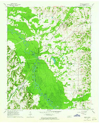
1961 Map of Mercer
USGS Topo · Published 1964About this map
The Hatchie River snakes through a wide, swampy floodplain known as Hatchie Bottom at the junction of Haywood, Madison, and Hardeman counties. This early 1960s landscape is defined by the heavy meanders of the river and a dense network of seasonal wetlands, including Bill Wilks Swamp and Chapman Swamp. The settlement of Mercer sits on higher ground to the northeast, served by the Louisville and Nashville railroad. Rural life is anchored by family-named landmarks and community centers such as Cloverport and the Beech Grove Ch, which also served as a school. Navigation history is preserved in the location of the Old Ferry Landing and the Steam Mill Ferry Road, pointing to a time when river crossings were vital for local commerce. Numerous oxbow lakes like Horseshoe Lake and Matthews Lake illustrate the shifting path of the river over decades.
Find a feature on this map
57 named features on this map. Tap any name to fly to it.
Don’t see what you’re looking for? This feature index may not catch every label — zoom into the map to look around manually.
Map Details
Editions of this 1961 Mercer Map
2 editions found
Other maps of this area

1950 · Sunnyhill
USGS Topo · 1:24,000

1951 · Sunnyhill
USGS Topo · 1:24,000

1956 · Blytheville
USGS Topo · 1:250,000

1959 · Blytheville
USGS Topo · 1:250,000

1959 · Westover
USGS Topo · 1:24,000

1959 · Denmark
USGS Topo · 1:24,000

1959 · Whiteville
USGS Topo · 1:24,000

1959 · Hillville
USGS Topo · 1:24,000

1961 · Bolivar West
USGS Topo · 1:24,000
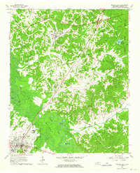
1961 · Bolivar East
USGS Topo · 1:24,000