
1950 Map of Sunnyhill
USGS Topo · Published 1981About this map
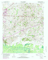
The Hatchie River meanders across the southern portion of this Haywood County landscape, shaping the wide alluvial terrain of the Hatchie Bottom. This area is preserved within the Hatchie National Wildlife Refuge, where a complex network of oxbows and backwaters like Horseshoe Cutoff and the Powell Lakes define the river's historic course. Further north, the elevation rises into a rolling agricultural upland where the regional transport network is anchored by the Louisville and Nashville railroad and the Broadway of America.
Find a feature on this map
40 named features on this map. Tap any name to fly to it.
Don’t see what you’re looking for? This feature index may not catch every label — zoom into the map to look around manually.
Map Details
Editions of this 1950 Sunnyhill Map
2 editions found
Other maps of this area

1950 · Brownsville
USGS Topo · 1:24,000

1951 · Brownsville
USGS Topo · 1:24,000

1951 · Sunnyhill
USGS Topo · 1:24,000

1952 · Dancyville
USGS Topo · 1:24,000

1952 · Stanton
USGS Topo · 1:62,500

1956 · Blytheville
USGS Topo · 1:250,000

1959 · Blytheville
USGS Topo · 1:250,000

1959 · Bells
USGS Topo · 1:24,000

1959 · Denmark
USGS Topo · 1:24,000

1959 · Hillville
USGS Topo · 1:24,000