
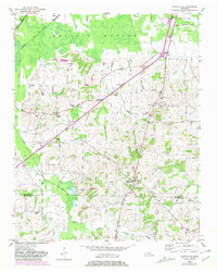
1952 Map of Dancyville
USGS Topo · Published 1952About this map
Dancyville sits at a crossroads in the early 1950s, serving as a hub for the small agricultural communities and family settlements of Haywood and Fayette Counties. The landscape is defined by the broad, low-lying drainage of Hatchie Bottom to the north and Big Muddy Bottom to the west, where the Big Muddy Canal channels the local waters. The Louisville and Nashville railroad cuts across the northwest corner near Shepp, marking the path of regional commerce. Numerous rural landmarks suggest a deep-rooted community life, from schools like Reeves Sch and Douglass Sch to the many country churches and burial grounds such as McKenzie Chapel, Antioch Cem, and St Johns Sch Cem. Scattered hamlets including Asbury, Ko Ko, and Wilkinson Corner are connected by a network of unimproved dirt and light-duty roads that navigate the subtle rises of Morton Hill and Richmond Hill.
Find a feature on this map
40 named features on this map. Tap any name to fly to it.
Don’t see what you’re looking for? This feature index may not catch every label — zoom into the map to look around manually.
Map Details
Editions of this 1952 Dancyville Map
2 editions found
Other maps of this area

1950 · Sunnyhill
USGS Topo · 1:24,000

1950 · Brownsville
USGS Topo · 1:24,000

1951 · Brownsville
USGS Topo · 1:24,000

1951 · Sunnyhill
USGS Topo · 1:24,000

1952 · Stanton
USGS Topo · 1:24,000

1952 · Lambert
USGS Topo · 1:24,000

1952 · Laconia
USGS Topo · 1:24,000

1952 · Stanton
USGS Topo · 1:62,500

1956 · Blytheville
USGS Topo · 1:250,000

1959 · Blytheville
USGS Topo · 1:250,000