
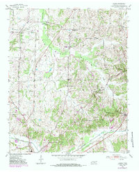
1952 Map of Laconia
USGS Topo · Published 1953About this map
Joyners Camp Ground and the curiously named Yum Yum anchor the northern reaches of this West Tennessee landscape, where the Big Muddy Canal cuts a straight path through the low-lying Big Muddy Bottom. The terrain is defined by the tension between the complex wetlands of the Loosahatchie River and the rising ground of Pontotoc Hill.
Find a feature on this map
38 named features on this map. Tap any name to fly to it.
Don’t see what you’re looking for? This feature index may not catch every label — zoom into the map to look around manually.
Map Details
Editions of this 1952 Laconia Map
2 editions found
Other maps of this area

1949 · Moscow
USGS Topo · 1:62,500

1951 · Hickory Valley
USGS Topo · 1:24,000

1952 · Stanton
USGS Topo · 1:24,000

1952 · Lambert
USGS Topo · 1:24,000

1952 · Dancyville
USGS Topo · 1:24,000

1952 · Stanton
USGS Topo · 1:62,500

1956 · Blytheville
USGS Topo · 1:250,000

1959 · Blytheville
USGS Topo · 1:250,000

1959 · Whiteville
USGS Topo · 1:24,000

1959 · Hillville
USGS Topo · 1:24,000