
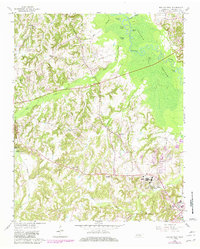
1961 Map of Bolivar West
USGS Topo · Published 1963About this map
Western State Hospital dominates the southeastern quadrant of this map, an expansive facility situated just west of Bolivar. The surrounding Hardeman County landscape is defined by the broad Hatchie Bottom, where the meandering Hatchie River is fed by various oxbows and wetlands including Clover Lakes, Turkey Pond, and Round Pond. This survey captures the rural layout of the early 1960s, punctuated by family-named landmarks and essential community centers like Parrana Chapel and Bethlehem Sch.
Find a feature on this map
38 named features on this map. Tap any name to fly to it.
Don’t see what you’re looking for? This feature index may not catch every label — zoom into the map to look around manually.
Map Details
Editions of this 1961 Bolivar West Map
2 editions found
Other maps of this area

1950 · Hebron
USGS Topo · 1:24,000

1950 · Middleburg
USGS Topo · 1:24,000

1951 · Middleburg
USGS Topo · 1:24,000

1951 · Hebron
USGS Topo · 1:24,000

1951 · Hickory Valley
USGS Topo · 1:24,000

1956 · Blytheville
USGS Topo · 1:250,000

1959 · Blytheville
USGS Topo · 1:250,000

1959 · Whiteville
USGS Topo · 1:24,000

1959 · Hillville
USGS Topo · 1:24,000
1961 · Mercer
USGS Topo · 1:24,000