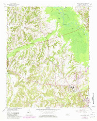
1961 Map of Bolivar West
USGS Topo · Published 1981About this map
Western State Hospital occupies a significant portion of the landscape west of Bolivar, surrounded by an extensive network of drainage basins and wetlands. The eastern edge of the quadrangle is dominated by the Hatchie River and its expansive Hatchie Bottom, a terrain marked by numerous oxbow ponds such as Round Pond and Brushy Pond. This area illustrates the classic West Tennessee topography of winding river bottoms contrasted with the low, rolling hills that house rural communities and family landmarks.
Find a feature on this map
35 named features on this map. Tap any name to fly to it.
Don’t see what you’re looking for? This feature index may not catch every label — zoom into the map to look around manually.
Map Details
Editions of this 1961 Bolivar West Map
2 editions found
Other maps of this area

1950 · Hebron
USGS Topo · 1:24,000

1950 · Middleburg
USGS Topo · 1:24,000

1951 · Middleburg
USGS Topo · 1:24,000

1951 · Hebron
USGS Topo · 1:24,000

1951 · Hickory Valley
USGS Topo · 1:24,000

1956 · Blytheville
USGS Topo · 1:250,000

1959 · Blytheville
USGS Topo · 1:250,000

1959 · Whiteville
USGS Topo · 1:24,000

1959 · Hillville
USGS Topo · 1:24,000

1961 · Bolivar West
USGS Topo · 1:24,000