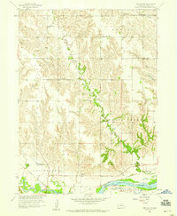
1958 Map of Merchiston
USGS Topo · Published 1959About this map
The Loup River and Cedar River converge in this 1958 survey of the Nebraska plains, creating a landscape defined by water and rail. The Union Pacific railroad tracks cut across the southern portion of the map, serving the small settlement of Merchiston, which sits just north of the river banks. This rural landscape is remarkably organized by its school districts, with a dense network of one-room schoolhouses including Rozencrantz Sch, Cloverdale Sch, and Sunnyside Sch distributed across the townships of Beaver and Council Creek.
Find a feature on this map
23 named features on this map. Tap any name to fly to it.
Don’t see what you’re looking for? This feature index may not catch every label — zoom into the map to look around manually.
Map Details
Editions of this 1958 Merchiston Map
This is the sole edition of this map. No revisions or reprints were ever made.
Other maps of this area

1896 · Stromsburg
USGS Topo · 1:125,000

1899 · St. Paul
USGS Topo · 1:125,000

1954 · Belgrade
USGS Topo · 1:24,000

1954 · Cedar Rapids SE
USGS Topo · 1:24,000

1955 · Broken Bow
USGS Topo · 1:250,000

1955 · Belgrade SE
USGS Topo · 1:24,000

1955 · Fremont
USGS Topo · 1:250,000

1956 · Broken Bow
USGS Topo · 1:250,000

1957 · Fremont
USGS Topo · 1:250,000

1958 · Fremont
USGS Topo · 1:250,000