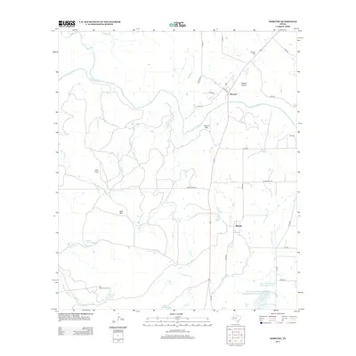
2013 Map of Mercury
USGS Topo · Published 2013About this map
The Colorado River meanders through this portion of McCulloch County, defining a landscape marked by intermittent creeks and cattle tanks. The small community of Mercury sits in the southeastern quadrant, while Winchell occupies the northern banks of the river near the intersection of several county roads. This area is characterized by low peaks and plateaus, including Morgan Mtn and Lost Mtn, rising above the surrounding drainages of Chamberlain Cr and Corn Cr. The map reveals the critical importance of water management in this Texas environment, shown through numerous named stock tanks like Beef Pasture Tank and larger projects such as the Deep Cr Watershed Reservoir Number Eight. Rural history is preserved in the locations of the Winchell Cem and Cox Cem, while the High Lonesome Windmill stands as a lonely landmark in the southwest corner.
Find a feature on this map
45 named features on this map. Tap any name to fly to it.
Don’t see what you’re looking for? This feature index may not catch every label — zoom into the map to look around manually.
Map Details
Editions of this 2013 Mercury Map
This is the sole edition of this map. No revisions or reprints were ever made.
Other maps of this area

1887 · Coleman
USGS Topo · 1:125,000

1889 · Coleman
USGS Topo · 1:125,000

1894 · Brady
USGS Topo · 1:125,000

1924 · Brady 2-a
USGS Topo · 1:48,000

1925 · Brady 1-b
USGS Topo · 1:48,000

1925 · Brady 1-a
USGS Topo · 1:48,000

1928 · Mercury
USGS Topo · 1:62,500

1928 · Waldrip
USGS Topo · 1:62,500

1950 · Mercury
USGS Topo · 1:62,500

1954 · Brownwood
USGS Topo · 1:250,000