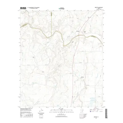
2016 Map of Mercury
USGS Topo · Published 2016About this map
The Colorado River carves a winding path along the triple border of McCulloch, Coleman, and Brown counties, defining a landscape of high points and named watering holes. The small settlements of Winchell and Mercury serve as local anchors, connected by the north-south transit of U.S. Route 377. High ground is marked by prominent features like Morgan Mtn and Lost Mtn, while the drainage basins are dotted with specialized water catchments such as Duck Pond Tank, Shotgun Tank, and Beef Pasture Tank. This ranching country relies on these distributed resources, as evidenced by the large-scale water management of the Deep Cr Watershed Reservoir Number Eight and the Soil Conservation Service Site 8 Lake. Genealogists may find value in the location of the Winchell Cem and Cox Cem, which rest near the river's path.
Find a feature on this map
50 named features on this map. Tap any name to fly to it.
Don’t see what you’re looking for? This feature index may not catch every label — zoom into the map to look around manually.
Map Details
Editions of this 2016 Mercury Map
This is the sole edition of this map. No revisions or reprints were ever made.
Other maps of this area

1887 · Coleman
USGS Topo · 1:125,000

1889 · Coleman
USGS Topo · 1:125,000

1894 · Brady
USGS Topo · 1:125,000

1924 · Brady 2-a
USGS Topo · 1:48,000

1925 · Brady 1-b
USGS Topo · 1:48,000

1925 · Brady 1-a
USGS Topo · 1:48,000

1928 · Mercury
USGS Topo · 1:62,500

1928 · Waldrip
USGS Topo · 1:62,500

1950 · Mercury
USGS Topo · 1:62,500

1954 · Brownwood
USGS Topo · 1:250,000