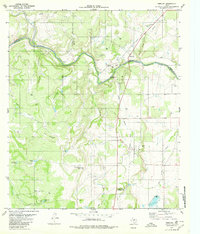
1979 Map of Mercury
USGS Topo · Published 1980About this map
The Colorado River carves a winding path through the borderlands of McCulloch, Coleman, and Brown counties, serving as the central geographic feature of this late 1970s landscape. Small settlements like Winchell and Mercury anchor the local geography, connected by a network of ranch roads and an Old Railroad Grade that speaks to former transit routes through the region. The terrain is defined by prominent elevations such as Morgan Mountain and High Lonesome, alongside numerous seasonal water sources named with ranching utility in mind, including Beef Pasture Tank and Goodnight Tank. A scattering of Gas Wells and Oil Wells across the hillsides indicates the energy extraction prevalent in this era. For those tracing local heritage, the map identifies the Winchell Cem and Cox Cem, while travelers of the time would recognize the Mercury Heart of Texas Roadside Park.
Find a feature on this map
38 named features on this map. Tap any name to fly to it.
Don’t see what you’re looking for? This feature index may not catch every label — zoom into the map to look around manually.
Map Details
Editions of this 1979 Mercury Map
2 editions found
Other maps of this area

1887 · Coleman
USGS Topo · 1:125,000

1889 · Coleman
USGS Topo · 1:125,000

1894 · Brady
USGS Topo · 1:125,000

1924 · Brady 2-a
USGS Topo · 1:48,000

1925 · Brady 1-b
USGS Topo · 1:48,000

1925 · Brady 1-a
USGS Topo · 1:48,000

1928 · Mercury
USGS Topo · 1:62,500

1928 · Waldrip
USGS Topo · 1:62,500

1950 · Mercury
USGS Topo · 1:62,500

1954 · Brownwood
USGS Topo · 1:250,000