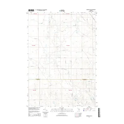
2014 Map of Meredith NW
USGS Topo · Published 2014About this map
The settlement of Calhoun sits near the center of this 2014 survey, which spans the boundary between Roscommon County and Clare County. This part of Michigan is defined by its complex hydrology, featuring numerous kettle lakes and branching creek systems. The western portion is dominated by the headwaters of Wolf Cr, including the East Branch Wolf Creek, while Townline Cr drains the central and southern sections. Genealogists and local historians can trace a dense network of forest roads and trails, such as Possum Trail and Yo Yo Ln, that provide access to isolated water bodies like Pup Lake, Rollway Lake, and the cluster known as Lost Lakes. These paths and drainage patterns reveal how the landscape has been navigated and managed long after the primary timber era, highlighting the persistent importance of natural landmarks in this glaciated terrain.
Find a feature on this map
66 named features on this map. Tap any name to fly to it.
Don’t see what you’re looking for? This feature index may not catch every label — zoom into the map to look around manually.
Map Details
Editions of this 2014 Meredith NW Map
This is the sole edition of this map. No revisions or reprints were ever made.
Other maps of this area

1954 · Traverse City
USGS Topo · 1:250,000

1956 · Houghton Lake
USGS Topo · 1:62,500

1957 · Harrison
USGS Topo · 1:62,500

1958 · Traverse City
USGS Topo · 1:250,000

1963 · Backus Lake
USGS Topo · 1:24,000

1963 · Prudenville
USGS Topo · 1:24,000

1969 · Meredith NW
USGS Topo · 1:24,000

1969 · Meredith
USGS Topo · 1:24,000

1969 · Meredith SW
USGS Topo · 1:24,000
1969 · Skeels
USGS Topo · 1:24,000