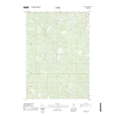
2023 Map of Meredith NW
USGS Topo · Published 2023About this map
Pup Lake and Duck Lake anchor the northern landscape of this region on the boundary between Roscommon and Clare counties. The area is defined by a complex network of recreational paths and water systems, including the Denton Creek Route Trl and the Lost Twin Lakes Pathway Trl. These trails weave through a terrain drained by Wolf Creek and its tributary, East Branch Wolf Creek, illustrating the heavy emphasis on forest management and outdoor access. In the southern portion, a cluster of smaller water bodies such as Elbow Lake, Rollway Lake, and Tuohy Lake suggest a localized geography of kettle lakes. The road system, featuring named routes like Van Sickle Rd and Tuscola Rd, follows a rigid section-line grid that reveals the historical township and range surveying legacy common across rural Michigan.
Find a feature on this map
68 named features on this map. Tap any name to fly to it.
Don’t see what you’re looking for? This feature index may not catch every label — zoom into the map to look around manually.
Map Details
Editions of this 2023 Meredith NW Map
This is the sole edition of this map. No revisions or reprints were ever made.
Other maps of this area

1954 · Traverse City
USGS Topo · 1:250,000

1956 · Houghton Lake
USGS Topo · 1:62,500

1957 · Harrison
USGS Topo · 1:62,500

1958 · Traverse City
USGS Topo · 1:250,000

1963 · Backus Lake
USGS Topo · 1:24,000

1963 · Prudenville
USGS Topo · 1:24,000

1969 · Meredith NW
USGS Topo · 1:24,000

1969 · Meredith
USGS Topo · 1:24,000

1969 · Meredith SW
USGS Topo · 1:24,000
1969 · Skeels
USGS Topo · 1:24,000