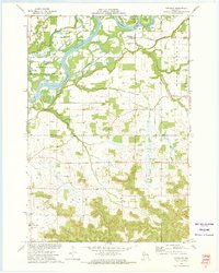
1972 Map of Meridean
USGS Topo · Published 1975About this map
The Chippewa River dominates this 1970s landscape, carving a wide path through the river bottoms of Dunn Co and Pepin Co. The river valley features a complex network of waterways, including Meridean Slough and Spring Brook, which surround Chippewa Island and Happy Island. The small settlement of Meridean sits along the Chicago Milwaukee St Paul and Pacific railroad, reflecting a rural landscape shaped by both the river's flow and the rail line's reach.
Find a feature on this map
32 named features on this map. Tap any name to fly to it.
Don’t see what you’re looking for? This feature index may not catch every label — zoom into the map to look around manually.
Map Details
Editions of this 1972 Meridean Map
This is the sole edition of this map. No revisions or reprints were ever made.
Other maps of this area

1929 · Durand
USGS Topo · 1:62,500

1932 · Durand
USGS Topo · 1:62,500

1932 · Mondovi
USGS Topo · 1:62,500

1934 · Elk Mound
USGS Topo · 1:62,500

1936 · Elk Mound
USGS Topo · 1:62,500

1940 · Menomonie
USGS Topo · 1:62,500

1942 · Menomonie
USGS Topo · 1:62,500

1953 · Eau Claire
USGS Topo · 1:250,000

1958 · Eau Claire
USGS Topo · 1:250,000

1964 · Eau Claire
USGS Topo · 1:250,000