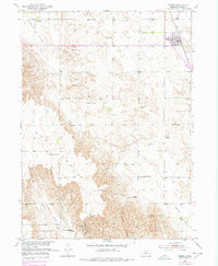
1951 Map of Merna
USGS Topo · Published 1978About this map
The village of Merna serves as the focal point for this mid-century survey of central Nebraska, situated where the Burlington Northern railroad cuts through the landscape. The surrounding rural townships, including Kilfoil and Ryno, reveal a systematic pattern of early educational and civic development. One particularly high concentration of country schools is evident here, with Sunshine Sch, Thomas Sch, Sunny Knoll Sch, Pleasant View Sch, Prairie Hill Sch, and Turner Valley Sch serving the farmstead families of the era.
Find a feature on this map
22 named features on this map. Tap any name to fly to it.
Don’t see what you’re looking for? This feature index may not catch every label — zoom into the map to look around manually.
Map Details
Editions of this 1951 Merna Map
3 editions found
Other maps of this area

1951 · Broken Bow SW
USGS Topo · 1:24,000

1951 · Lillian
USGS Topo · 1:24,000

1951 · Callaway NW
USGS Topo · 1:24,000

1951 · Anselmo
USGS Topo · 1:24,000

1951 · Broken Bow
USGS Topo · 1:24,000

1951 · Merna
USGS Topo · 1:24,000

1951 · Anselmo SW
USGS Topo · 1:24,000

1951 · Callaway SE
USGS Topo · 1:24,000

1951 · Callaway
USGS Topo · 1:24,000

1955 · Broken Bow
USGS Topo · 1:250,000