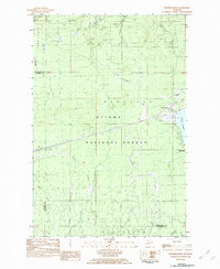
1982 Map of Merriweather
USGS Topo · Published 1982About this map
Merriweather and the surrounding wilderness of the Ottawa National Forest define this landscape in the early 1980s. The settlement sits along the northern shores of Lake Gogebic, where the Ontonagon County Park and a local Trailer Park serve as focal points for recreation and lakeside living. The area is heavily marked by its water systems, including the Big Iron River and the distinctive Haskin Rapid to the north.
Find a feature on this map
21 named features on this map. Tap any name to fly to it.
Don’t see what you’re looking for? This feature index may not catch every label — zoom into the map to look around manually.
Map Details
Editions of this 1982 Merriweather Map
This is the sole edition of this map. No revisions or reprints were ever made.
Other maps of this area

1949 · Bergland NE
USGS Topo · 1:24,000

1955 · Marenisco
USGS Topo · 1:62,500

1955 · Marenisco
USGS Topo · 1:24,000

1955 · Wakefield
USGS Topo · 1:62,500

1955 · Wakefield NE
USGS Topo · 1:24,000

1956 · Bergland NE
USGS Topo · 1:24,000

1956 · Bergland
USGS Topo · 1:62,500

1956 · Thomaston
USGS Topo · 1:62,500

1958 · Iron River
USGS Topo · 1:250,000

1960 · Iron River
USGS Topo · 1:250,000
Featured Places
- Wakefield Township, MI
- Marenisco Township, MI
- Carp Lake Township, MI
- Merriweather, MI
- Bergland Township, MI