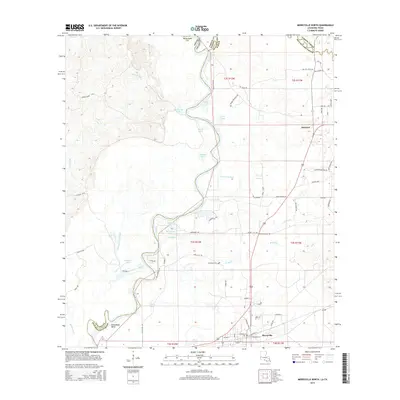
2015 Map of Merryville North
USGS Topo · Published 2015About this map
The Sabine River forms the state boundary between Texas and Louisiana in this 2015 study, carving a complex path through the bottomlands of Beauregard Parish. This riparian landscape is defined by its oxbow lakes and winding waterways, including Alligator Lake, Palmer Lake, and the distinctive Steamboat Bend. The settlement of Merryville occupies the southern edge of the sheet, while the rural landscape to the north is dotted with smaller communities like Junction and Frazer. Long-standing local family history is anchored by the Hennigan Cem, situated near Bridge Cr. The survey illustrates a terrain where water dictates movement, with features such as Eaves Old River and Pole Slough framing the low-lying basins. The transport network consists of local roads like Eli Field Rd and Browning Rd, providing access to the various sloughs and lakes that characterize this border region.
Find a feature on this map
75 named features on this map. Tap any name to fly to it.
Don’t see what you’re looking for? This feature index may not catch every label — zoom into the map to look around manually.
Map Details
Editions of this 2015 Merryville North Map
This is the sole edition of this map. No revisions or reprints were ever made.
Other maps of this area

1935 · Wilson Lake
USGS Topo · 1:31,680

1946 · Merryville
USGS Topo · 1:31,680

1947 · Singer
USGS Topo · 1:31,680

1947 · Pujo
USGS Topo · 1:31,680

1947 · Knight
USGS Topo · 1:31,680

1947 · Wilson Lake
USGS Topo · 1:31,680

1947 · Bivens
USGS Topo · 1:31,680

1949 · Evans
USGS Topo · 1:31,680

1952 · Lake Charles
USGS Topo · 1:250,000
1954 · Pujo
USGS Topo · 1:31,680