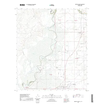
2018 Map of Merryville North
USGS Topo · Published 2018About this map
Sabine River bottomlands dominate this survey of the Louisiana-Texas border, where the river's meandering course creates a complex network of oxbows and backwaters. In the northern reaches, features like Alligator Lake, Chain Lakes, and Armstrong Lake reflect the shifting hydrology of the river valley. The settlement of Merryville occupies the higher ground in the southeast corner, characterized by a grid of streets including S Railroad St and N Tram Rd, hinting at the area's timber and rail history. To the north lies the community of Junction, situated near the confluence of several parish roads. Genealogists will find the Hennigan Cems centrally located among the numerous sloughs and lakes, such as Kimmey Lake and Moon Lake, which define the wetlands of western Beauregard Parish. The boundary between Texas and Louisiana follows the main channel, passing distinctive river features like Steamboat Bend.
Find a feature on this map
70 named features on this map. Tap any name to fly to it.
Don’t see what you’re looking for? This feature index may not catch every label — zoom into the map to look around manually.
Map Details
Editions of this 2018 Merryville North Map
This is the sole edition of this map. No revisions or reprints were ever made.
Other maps of this area

1935 · Wilson Lake
USGS Topo · 1:31,680

1946 · Merryville
USGS Topo · 1:31,680

1947 · Singer
USGS Topo · 1:31,680

1947 · Pujo
USGS Topo · 1:31,680

1947 · Knight
USGS Topo · 1:31,680

1947 · Wilson Lake
USGS Topo · 1:31,680

1947 · Bivens
USGS Topo · 1:31,680

1949 · Evans
USGS Topo · 1:31,680

1952 · Lake Charles
USGS Topo · 1:250,000
1954 · Pujo
USGS Topo · 1:31,680